
Historic Cities
Shinjuku
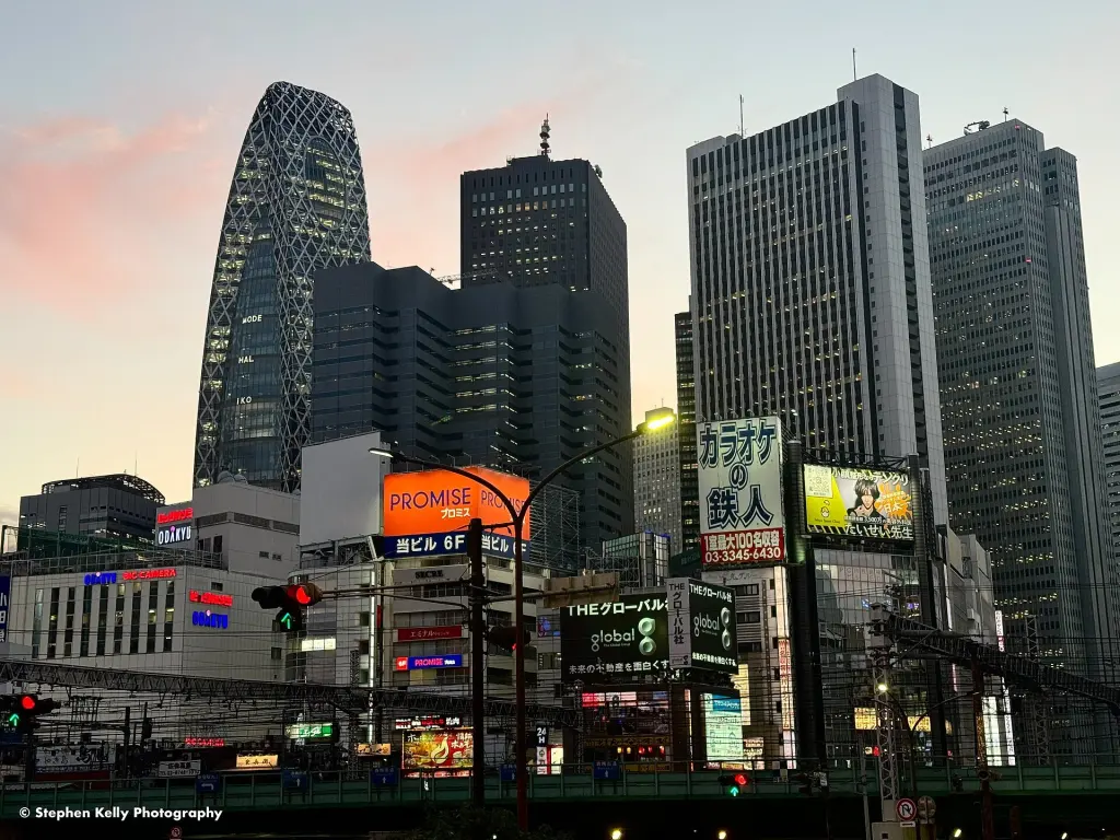
Image: Stephen Kelly / Wikimedia Commons · Creative Commons Attribution 2.0 Generic
Shinjuku is both one of Tokyo’s twenty-three special wards and the name commonly used for the vast commercial and transport district around Shinjuku Station. The two meanings overlap but are not identical: the ward also includes Yotsuya, Kagurazaka, Ōkubo, Takadanobaba, and residential neighborhoods far from the station. Its name descends from Naitō Shinjuku, an Edo-period post town established on the Kōshū Kaidō. The opening and expansion of the railway station shifted the area toward metropolitan commerce, while postwar markets, theaters, bars, offices, and later high-rise construction produced distinct eastern and western cityscapes. Today Nishi-Shinjuku contains the Tokyo Metropolitan Government Building, Kabukichō is a major entertainment district, and Shinjuku Gyoen preserves a large garden landscape. Shinjuku is best understood as a layered urban center, not as a synonym for nightlife alone.
Overview
| Japanese name | 新宿区 / 新宿 |
|---|---|
| Romanization | Shinjuku-ku / Shinjuku |
| Administrative status | Special ward of Tokyo |
| Ward established | 15 March 1947 |
| Historical origin | Naitō Shinjuku post town |
| Major transport node | Shinjuku Station and adjoining terminals |
| Civic center | Shinjuku City Office |
| Metropolitan landmark | Tokyo Metropolitan Government Building, Nishi-Shinjuku |
The ward and the station district
Shinjuku City, or Shinjuku Ward, is an administrative municipality extending across a broad part of central-western Tokyo. In everyday speech, “Shinjuku” often means the area around the station, especially Nishi-Shinjuku, Kabukichō, Shinjuku-sanchōme, and the major retail streets.
This distinction explains apparent contradictions. Kagurazaka and Ōkubo are within the ward but have identities of their own, while parts of the station complex and Shinjuku Gyoen approach neighboring jurisdictions. An encyclopedic account must therefore state whether it is discussing the ward, the historical settlement, or the station-centered district.
Naitō Shinjuku and the Kōshū Kaidō
The name developed from Naitō Shinjuku, a post station established in 1698 on land associated with the Naitō family. Shinjuku means “new post station.” It provided a nearer stopping point on the Kōshū Kaidō west of Edo and became part of the road and entertainment economy surrounding travel.
The post town was abolished for a period in the early eighteenth century and later restored. Its history survives in the name, in local museum collections, and in the landscape around Shinjuku Gyoen, whose grounds developed from part of the Naitō estate.
From railway stop to metropolitan center
Shinjuku Station opened in 1885 on a then peripheral section of the line that became the Yamanote Line. Connections added by national and private railways gradually turned it into a western gateway to central Tokyo. Keio and Odakyu terminals, subway lines, and bus services reinforced the concentration.
The station is not one simple building. Separate companies, concourses, underground passages, department stores, and neighboring stations form a connected but institutionally divided complex. The network explains Shinjuku’s scale as a meeting place and commercial center more accurately than a passenger superlative alone.
War, destruction, and postwar markets
Air raids destroyed large areas of Shinjuku in 1945. Around the station, informal and licensed markets emerged amid shortages and displaced urban life. The Edo-Tokyo Museum preserves this history through materials and a reconstruction of the night market landscape.
Postwar rebuilding brought cinemas, theaters, bars, small restaurants, and new retail buildings. Some narrow alleys and entertainment zones retain spatial traces of this period even as land values and redevelopment have repeatedly transformed the district.
The east side: retail and entertainment
East of the station are department stores, Shinjuku-sanchōme, Kabukichō, and dense streets of restaurants, cinemas, bars, music venues, and shops. Kabukichō was planned as a postwar entertainment district; its name refers to a kabuki theater that was proposed but never built.
Golden Gai is known for very small bars occupying a compact street pattern, while Hanazono Shrine provides a religious and festival site within the entertainment landscape. These places differ in history and regulation and should not be collapsed into a single image of a “red-light district.”
The west side: waterworks land and skyscrapers
West of the station, the former Yodobashi Water Purification Plant created a large redevelopment site after its functions moved in the 1960s. High-rise offices and hotels transformed Nishi-Shinjuku into a planned business center distinct from the older commercial fabric to the east.
The Tokyo Metropolitan Government moved its headquarters to Nishi-Shinjuku in 1991. The twin-towered main building became both a civic institution and a visual marker of Tokyo’s decentralized metropolitan structure.
Shinjuku Gyoen and the older landscape
Shinjuku Gyoen developed from the Naitō family estate, later became an agricultural experimental site and imperial garden, and opened to the public as a national garden in 1949. Its present design combines a formal French garden, an English landscape garden, and Japanese garden areas.
The garden complicates the idea of Shinjuku as continuous urban intensity. It also preserves histories of horticultural science, imperial ceremony, wartime destruction, and postwar public use within walking distance of the station district.
Ōkubo, Kagurazaka, and a diverse ward
North and east of the station district, the ward contains neighborhoods with different social histories. Ōkubo is associated with successive migrant communities and contemporary Korean and other Asian businesses. Kagurazaka combines an older entertainment-district history with temples, restaurants, slopes, and later international institutions.
Universities, hospitals, publishing businesses, small factories, apartment districts, and religious sites further broaden the ward. The resident city cannot be understood solely through the station’s daytime population or the nighttime economy of Kabukichō.
Reading Shinjuku as a layered city
Shinjuku brings several phases of Tokyo’s growth into close proximity: an Edo road settlement, Meiji railway expansion, prewar suburbanization, wartime destruction, postwar markets, high-rise planning, and multinational everyday life. East-west contrasts are useful, but they do not capture the ward’s full geography.
The most durable boundary is conceptual. “Shinjuku” may name an administrative ward, a historical post town, a station complex, or a popular image of metropolitan Tokyo. Stating which Shinjuku is meant turns an iconic place into a legible urban history.
Sources
Last updated:


.jpg)